Towns starting with U - V
Summation of Names in towns starting with Uand V
This section will allow you check, and see if any of the names you are researching are in any of the towns starting with an "U and V" . To see this table, click on the header above.
Udelfangen
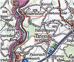 Udelfangen is located in the southern portion of the study area.
Data in this file covers the period of 1730 to 1870 from Catholic Church
records in the area. The four closest towns around Udelfangen are
Trierweiler, Sirzenich, Fusenich, and Born. The five most common names in this file are Berschens, Burg, Gottong, Schmitt, and Trierweiler. There are 404 names in this file. If you want to look at the complete file, click on Udelfangen.
Udelfangen is located in the southern portion of the study area.
Data in this file covers the period of 1730 to 1870 from Catholic Church
records in the area. The four closest towns around Udelfangen are
Trierweiler, Sirzenich, Fusenich, and Born. The five most common names in this file are Berschens, Burg, Gottong, Schmitt, and Trierweiler. There are 404 names in this file. If you want to look at the complete file, click on Udelfangen.
Udersdorf
 Udersdorf is located in the east-central portion of the study area.
Data in this file covers the period of 1814 to 1865 from Catholic Church
records in the area. The four closest towns around Udersdorf are
Trittscheid, Weyersbach, Daun, and Niederstadfeld. The seven most common names in this file are Brost, Jungels, Ludwig, Michels, Muller, Schmitz, and Willems. There are 842 names in this file. If you want to look at the complete file, click on Udersdorf.
Udersdorf is located in the east-central portion of the study area.
Data in this file covers the period of 1814 to 1865 from Catholic Church
records in the area. The four closest towns around Udersdorf are
Trittscheid, Weyersbach, Daun, and Niederstadfeld. The seven most common names in this file are Brost, Jungels, Ludwig, Michels, Muller, Schmitz, and Willems. There are 842 names in this file. If you want to look at the complete file, click on Udersdorf.
Udelhoven
 Uedelhoven is located in the northern portion of the study area.
Data in this file covers the period of 1715 to 1875 from Catholic Church
records in the area. The following LDS tape was used in developing this file: 0560650. The four closest towns around Uedelhoven are
Dollendorf, Ahrhuette, Uxheim, and Dorsel. The 10 most common names in this file are Bonzelets, Eich, Frings, Hellendahl, Koch, Meyer, Muller, Pick, Wafsong, and Wagener. There are 1219 names in this file. If you want to look at the complete file, click on Uedelhoven.
Uedelhoven is located in the northern portion of the study area.
Data in this file covers the period of 1715 to 1875 from Catholic Church
records in the area. The following LDS tape was used in developing this file: 0560650. The four closest towns around Uedelhoven are
Dollendorf, Ahrhuette, Uxheim, and Dorsel. The 10 most common names in this file are Bonzelets, Eich, Frings, Hellendahl, Koch, Meyer, Muller, Pick, Wafsong, and Wagener. There are 1219 names in this file. If you want to look at the complete file, click on Uedelhoven.
Udler
Udler is located in the eastern portion of the study
area. Data in this file covers the period of 1760 to 1862 from Catholic Church records in the area. The four closest towns around Udler
are Gillenfeld, Saxler, Brockscheid, and Tettscheid. The four most common names in this file are Neidhofen, Schmitz, Schneider, and Theissen. There are 493 names in this file. If you want to look at the complete file, click on Udler.
Ulmen
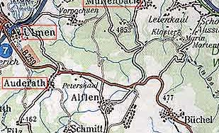 Ulmen is located in the eastern portion of the study area.
Data in this file covers the period of 1648 to 1840 from Catholic Church
records in the area. The four closest towns around Ulmen are Auderath, Meiserich, Schonbach, and Utzerath. The four most common names in this file are Dreys, Frantzen, Weber, and Wilwerscheid. There are 2548 names in this file. If you want to look at the complete file, click on Ulmen.
Undorf
Ulmen is located in the eastern portion of the study area.
Data in this file covers the period of 1648 to 1840 from Catholic Church
records in the area. The four closest towns around Ulmen are Auderath, Meiserich, Schonbach, and Utzerath. The four most common names in this file are Dreys, Frantzen, Weber, and Wilwerscheid. There are 2548 names in this file. If you want to look at the complete file, click on Ulmen.
Undorf
 Undorf is located in the southern portion of the study area.
Data in this file covers the period of 1710 to 1777 from Catholic Church
records in the area. The closest town to Undorf is Dockendorf. The two most common names in this file are Goebel and Schilling. There are 59 names in this file. If you want to look at the complete file, click on Undorf.
Undorf is located in the southern portion of the study area.
Data in this file covers the period of 1710 to 1777 from Catholic Church
records in the area. The closest town to Undorf is Dockendorf. The two most common names in this file are Goebel and Schilling. There are 59 names in this file. If you want to look at the complete file, click on Undorf.
Upperhausen
 Upperhausen is located in the northern portion of the study area.
Data in this file covers the period of 1779 to 1861 from Catholic Church
records in the area. The four closest towns around Upperhausen are Berkoth, Burscheid, Altscheuren, and Scheuren. The two most common names in this file are Keilen and Weires. There are 96 names in this file. If you want to look at the complete file, click on Upperhausen.
Urb
Upperhausen is located in the northern portion of the study area.
Data in this file covers the period of 1779 to 1861 from Catholic Church
records in the area. The four closest towns around Upperhausen are Berkoth, Burscheid, Altscheuren, and Scheuren. The two most common names in this file are Keilen and Weires. There are 96 names in this file. If you want to look at the complete file, click on Upperhausen.
Urb
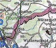 Urb is located in the western portion of the study area.
Data in this file covers the period of 1722 to 1830 from Catholic Church
records in the area. The four closest towns around Urb are
Mutzenich, Winterscheid, Ihren, and Weppeler. The three most common names in this file are Jacobi, Peters, and Reiters. There are 124 names in this file. If you want to look at the complete file, click on Urb.
Urb is located in the western portion of the study area.
Data in this file covers the period of 1722 to 1830 from Catholic Church
records in the area. The four closest towns around Urb are
Mutzenich, Winterscheid, Ihren, and Weppeler. The three most common names in this file are Jacobi, Peters, and Reiters. There are 124 names in this file. If you want to look at the complete file, click on Urb.
Urhausen
 Urhausen is located in the western portion of the study area.
Data in this file covers the period of 1707 to 1791 from Catholic Church
records in the area. ( I am unsure whether Urhausen is a separate town, or another spelling of Irrhausen.) The closest town to Urhausen is Daleiden. The two most common names in this file are Merckes and Muller. There are 41 names in this file. If you want to look at the complete file, click on Urhausen.
Urhausen is located in the western portion of the study area.
Data in this file covers the period of 1707 to 1791 from Catholic Church
records in the area. ( I am unsure whether Urhausen is a separate town, or another spelling of Irrhausen.) The closest town to Urhausen is Daleiden. The two most common names in this file are Merckes and Muller. There are 41 names in this file. If you want to look at the complete file, click on Urhausen.
Urschmitt
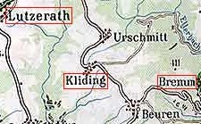 Urschmitt is located in the eastern portion of the study area.
Data in this file covers the period of 1760 to 1798 from Catholic Church
records in the area. The closest four towns to Urschmitt are Cliding, Beuren, Lutzerath, and Weiler. The two most common names in this file are Jahnen and Schneider. There are 179 names in this file. If you want to look at the complete file, click on Urschmitt.
Urschmitt is located in the eastern portion of the study area.
Data in this file covers the period of 1760 to 1798 from Catholic Church
records in the area. The closest four towns to Urschmitt are Cliding, Beuren, Lutzerath, and Weiler. The two most common names in this file are Jahnen and Schneider. There are 179 names in this file. If you want to look at the complete file, click on Urschmitt.
Usch
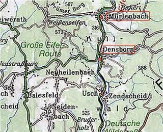 Usch is located in the central portion of the study area. Data in this file covers the period of 1767 to 1867 to from Catholic Church records in the area. The four closest towns around Usch are Zendscheid, Balesfeld, Densborn, Neuheilenbach. The four most common names in this file are Berscheid, Elsen, Mergen, and Schweisthal. There are 295 names in this file. If you want to look at the complete file, click on Usch.
Uttfeld
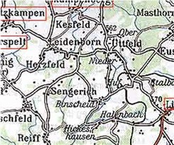 Uttfeld is located in the central portion of the study area. Data in this file covers the period of 1700 to 1806 from Catholic Church records in the area. The four closest towns around Uttfeld are Kesfeld, Leidenborn, Euscheid, and Herzfeld. The two most common names in this file are Schonecken and Thommes. There are 103 names in this file. If you want to look at the complete file, click on Uttfeld.
Utzerath
Uttfeld is located in the central portion of the study area. Data in this file covers the period of 1700 to 1806 from Catholic Church records in the area. The four closest towns around Uttfeld are Kesfeld, Leidenborn, Euscheid, and Herzfeld. The two most common names in this file are Schonecken and Thommes. There are 103 names in this file. If you want to look at the complete file, click on Uttfeld.
Utzerath
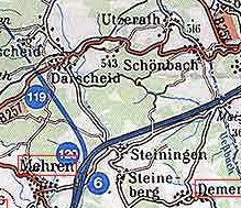 Utzerath is located in the eastern portion of the study area. Data in this file covers the period of 1804 to 1864 from Catholic Church records in the area. The four closest towns around Utzerath are Schombach, Darscheid, Gefell, and Horscheid. The three most common names in this file are Daun, Scheid, and Schmitz. There are 194 names in this file. If you want to look at the complete file, click on Utzerath.
Uxheim
Utzerath is located in the eastern portion of the study area. Data in this file covers the period of 1804 to 1864 from Catholic Church records in the area. The four closest towns around Utzerath are Schombach, Darscheid, Gefell, and Horscheid. The three most common names in this file are Daun, Scheid, and Schmitz. There are 194 names in this file. If you want to look at the complete file, click on Utzerath.
Uxheim
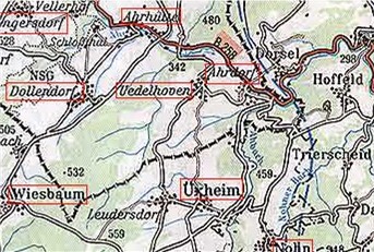 Uxheim is located in the northern portion of the study area.
Data in this file covers the period of 1803 to 1898 from Catholic Church
records in the area. The following LDS tape was used in developing this file: 0176279. The four closest towns around Uxheim are Leudersdorf, Kerpen, Uedelhoven, and Dankerath. The seven most common names in this file are Cremer, Klein, Moersch, Pinn, Schneider, Simon, and Vellen. There are 639 names in this file. If you want to look at the complete file, click on Uxheim.
Uxheim is located in the northern portion of the study area.
Data in this file covers the period of 1803 to 1898 from Catholic Church
records in the area. The following LDS tape was used in developing this file: 0176279. The four closest towns around Uxheim are Leudersdorf, Kerpen, Uedelhoven, and Dankerath. The seven most common names in this file are Cremer, Klein, Moersch, Pinn, Schneider, Simon, and Vellen. There are 639 names in this file. If you want to look at the complete file, click on Uxheim.
Veldenz
 Veldenz is located in the southern portion of the study area. Data in this file covers the period of 1700 to 1798 from Catholic Church records in the area. The four closest towns around Veldenz are Mulheim nr Wittlich, Burgen, Monzelfeld, and Dusemond. The two most common names in this file are Clasen and Weber. There are 120 names in this file. If you want to look at the complete file, click on Veldenz.
Verschneid
Veldenz is located in the southern portion of the study area. Data in this file covers the period of 1700 to 1798 from Catholic Church records in the area. The four closest towns around Veldenz are Mulheim nr Wittlich, Burgen, Monzelfeld, and Dusemond. The two most common names in this file are Clasen and Weber. There are 120 names in this file. If you want to look at the complete file, click on Veldenz.
Verschneid
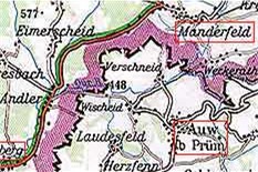 Verschneid is located in the western portion of the study area. Data in this file covers the period of 1724 to 1796 from Catholic Church records in the area. The four closest towns around Verschneid are Manderfeld, Auw d Prum, Herzfenn, and Laudesfeld. The two most common names in this file are Cortges and Dresen. There are 67 names in this file. If you want to look at the complete file, click on Verschneid.