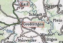
 Karl is located in the central portion of the study area. Data in this file covers the period of 1725 to 1848 from Catholic Church records in the area. The four closest towns around Karl are Schladt, Groblittgen, Giperath, and Himmerad. The four most common names in this file are Heck, Kyll, Muller, and Schue. There are 676 names in this file. If you want to look at the complete file, click on Karl.
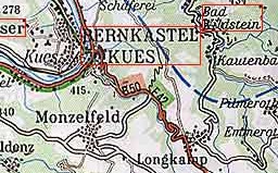
 Kaschenbach is located in the central portion of the study area. Data in this file covers the period of 1780 to 1852 from Catholic Church records in the area. The four closest towns around Kaschenbach are Niederweis, Gikzem, Mechel, Idesheim. The three most common names in this file are Arnoldi, Bares, and Muller. There are 134 names in this file. If you want to look at the complete file, click on Kaschenbach.
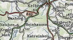 Kelberg is located in the northeastern portion of the study area. Data in this file covers the period of 1655 to 1838 from Catholic Church records in the area. The four closest towns around Kelburg are Gelenburg, Boxberg, Zermullen, and Bongard. The eight most common names in this file are Bongarts, Caspers, Faber, Hens, Muller, Schmitz, Willems, and Zenzen. There are 841 names in this file. If you want to look at the complete file, click on Kelberg.
 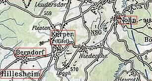 Kerpen is located in the northern portion of the study area. Data in this file covers the period of 1658 to 1892 from Catholic Church records in the area. The four closest towns around Kerpen are Berndorf, Niederehe,
Flesten, and Leudersdorf. The 12 most common names in this file are Engels, Hennes, Hermes, Hilgers, Keul, Lentzen, Leyendecker, Metzen, Muller, Pontzelets, Reetz, and Schmitz. There are 2662 names in this file. If you want to look at the complete file, click on Kerpen.
Kerpen is located in the northern portion of the study area. Data in this file covers the period of 1658 to 1892 from Catholic Church records in the area. The four closest towns around Kerpen are Berndorf, Niederehe,
Flesten, and Leudersdorf. The 12 most common names in this file are Engels, Hennes, Hermes, Hilgers, Keul, Lentzen, Leyendecker, Metzen, Muller, Pontzelets, Reetz, and Schmitz. There are 2662 names in this file. If you want to look at the complete file, click on Kerpen.
 Kenn is located in the southern portion of the study area on the Moselle River. Data in this file covers the period of 1730 to 1880 from Catholic Church records in the area. The four closest towns around Kenn are Ruwer, Ehrang, Fastrau, and Schweich. The seven most common names in this file are Bauerschmitt, Heiderich, Hitsamer, Palzer, Schiff, Schneider, and Thesen. There are 2865 names in this file. If you want to look at the complete file, click on Kenn.
 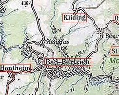 Kennfuss is located in the southeastern portion of the study area on the Moselle River. Data in this file covers the period of 1763 to 1855 from Catholic Church records in the area. The four closest towns around Kennfuss are Bad Bertrich, Kliding, Hontheim, and Beuren. The six most common names in this file are Berres, Geiffer, Johan, Rieser, Steffes, and Weinand. There are 836 names in this file. If you want to look at the complete file, click on Kennfuss.
  Kesten is located in the southern portion of the study area on the Moselle River. Data in this file covers the period of 1686 to 1870 from Catholic Church records in the area. The four closest towns around Kesten are Monzel, Wintrich, Piesport, and Brauneburg. The 11 most common names in this file are Birenfeld, Bollig, Dumont, Ferres, Goergen, Haas, Jungling, Kilurg, Klein, Licht, and Winter. There are 2345 names in this file. If you want to look at the complete file, click on Kesten.
 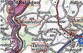 Kersch is located in the southern portion of the study area. Data in this file covers the period of 1798 to 1881 from Catholic Church records in the area. The four closest towns around Kersch are Wintersdorf, Hohensonne, Ralingen, and Befselich. The most common name in this file is Winnebeck. There are 47 names in this file. If you want to look at the complete file, click on Kersch.
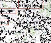 Kesfeld is located in the central portion of the study area. Data in this file covers the period of 1740 to 1872 from Catholic Church records in the area. The four closest towns around Kesfeld are Leidenborn, Heckhuscheid, Berg, and Niederuttfeld. The five most common names in this file are Ballman, Heinen, Horpers, Spoden, abd Zehren. There are 333 names in this file. If you want to look at the complete file, click on Kesfeld.
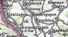 Kevenig is located in the southern portion of the study area. Data in this file covers the period of 1779 to 1862 from Catholic Church records in the area. The four closest towns around Kevenig are Cruchten, Niedersgegen, Gentingen, and Hommerdingen. The most common name in this file is Curanz. There are 17 names in this file. If you want to look at the complete file, click on Kevenig.
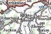 Kickeshausen is located in the central portion of the study area. Data in this file covers the period of 1700 to 1866 from Catholic Church records in the area. The four closest towns around Kickeshausen are Olmscheid, Neurath, Emmelbaum, and Daleiden. The two most common names in this file are Daus and Pick. There are 165 names in this file. If you want to look at the complete file, click on Kickeshausen.
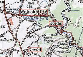 Kimlingen is located in the central portion of the study area. Data in this file covers the period of 1815 to 1872 from Catholic Church records in the area. The four closest towns around Kimlingen are Cordel, Butzweiler, Mohn, and Newel. The two most common names in this file are Muller and Schneider. There are 71 names in this file. If you want to look at the complete file, click on Kimlingen.
 Kirschweiler is located in the northeastern portion of the study area. Data in this file covers the period of 1741 to 1870 from Catholic Church records in the area. The four closest towns around Kirschweiler are Berlingen, Gees, Hinterweiler, and Steinborn. The seven most common names in this file are Cremer, Hunz, Michels, Muller, Oehman, Surges, and Wirtz. There are 1156 names in this file. If you want to look at the complete file, click on Kirschweiler.
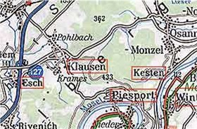 Klausen is located in the southeast portion of the study area. Data in this file covers the period of 1803 to 1867 from Catholic Church records in the area. The four closest towns around Klausen are Crames, Pohlbach, Esch, and Piesport. The three most common names in this file are Antz, Haas, and Rhoden. There are 109 names in this file. If you want to look at the complete file, click on Klausen.
 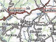 Kleinweis is located in the central portion of the study area. Data in this file covers the period of 1802 to 1871 from Catholic Church records in the area. The closest town to Kleinweis is Emmelbaum. The most common names in this file is Meyer. There are 41 names in this file. If you want to look at the complete file, click on Kleinweis.

 Koosbusch is located in the central portion of the study area. Data in this file covers the period of 1835 to 1867. from Catholic Church records in the area. The four closest towns around Koosbusch are Wiersdorf,
Hutterscheid, Weidingen, and Hamm. The three most common names in this file are Fuchs, Mertes, and Weiler. There are 117 names in this file. If you want to look at the complete file, click on Koosbusch.
Koosbusch is located in the central portion of the study area. Data in this file covers the period of 1835 to 1867. from Catholic Church records in the area. The four closest towns around Koosbusch are Wiersdorf,
Hutterscheid, Weidingen, and Hamm. The three most common names in this file are Fuchs, Mertes, and Weiler. There are 117 names in this file. If you want to look at the complete file, click on Koosbusch.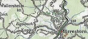 Kopp is located in the central portion of the study area. Data in this file covers the period of 1688 to 1865 from Catholic Church records in the area. The four closest towns around Kopp are Birresborn, Hersdorf,
Wallersheim, and Eigelbach. The seven most common names in this file are Cremer, Fritschen, Hoffman, Mertes, Meyer, Mucken, and Zirden. There are 703 names in this file. If you want to look at the complete file, click on Kopp.
Kopp is located in the central portion of the study area. Data in this file covers the period of 1688 to 1865 from Catholic Church records in the area. The four closest towns around Kopp are Birresborn, Hersdorf,
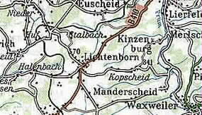
Wallersheim, and Eigelbach. The seven most common names in this file are Cremer, Fritschen, Hoffman, Mertes, Meyer, Mucken, and Zirden. There are 703 names in this file. If you want to look at the complete file, click on Kopp.  Kopscheid is located in the central portion of the study area. Data in this file covers the period of 1700 to 1829 from Catholic Church records in the area. The four closest towns around Kopscheid are Manderscheid, Lichtenborn, Halenbach, and Waxweiler. The five most common names in this file are grunnes, Hacker, Kewers, Reichert,and Thelen. There are 239 names in this file. If you want to look at the complete file, click on Kopscheid.
 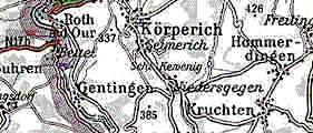 Koerperich is located in the southwestern portion of the study area. Data in this file covers the period of 1691 to 1876 from Catholic Church records in the area. The four closest towns around Koerperich are Niedergegen, Gentingen, Hommeldingen, and Cruchten. The six most common names in this file are Adams, Frascht, Geisen, Goedert, Schmid, and Wagener. There are 1321 names in this file. If you want to look at
the complete file, click on Koerperich.
Koerperich is located in the southwestern portion of the study area. Data in this file covers the period of 1691 to 1876 from Catholic Church records in the area. The four closest towns around Koerperich are Niedergegen, Gentingen, Hommeldingen, and Cruchten. The six most common names in this file are Adams, Frascht, Geisen, Goedert, Schmid, and Wagener. There are 1321 names in this file. If you want to look at
the complete file, click on Koerperich. 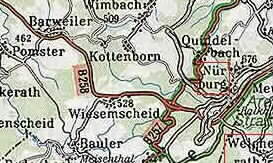 Koettelbach is located in the north-central portion of the study area. Data in this file covers the period of 1656 to 1838 from Catholic Church records in the area. The four closest towns around Koettelbach are Kelberg, Bereborn, Mosbruch, and Huenerbach. The five most common
names in this file are Cremer, Gilles, Meyer, Reif, and Wagener. There are 451 names in this file. If you want to look at the complete file, click on Koettelbach.
Koettelbach is located in the north-central portion of the study area. Data in this file covers the period of 1656 to 1838 from Catholic Church records in the area. The four closest towns around Koettelbach are Kelberg, Bereborn, Mosbruch, and Huenerbach. The five most common
names in this file are Cremer, Gilles, Meyer, Reif, and Wagener. There are 451 names in this file. If you want to look at the complete file, click on Koettelbach.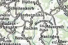 Koxhausen is located in the central portion of the study area. Data in this file covers the period of 1808 to 1875 from Catholic Church records in the area. The four closest towns around Koxhausen are Muxerath, Nasingen,Berscheid, and Rodershausen. The seven most common names in this file are Antoni, Kandel, Klein, Meyer, Peters, Svhmitz, and Theis. There are 926 names in this file. If you want to look at the complete file, click on Koxhausen.
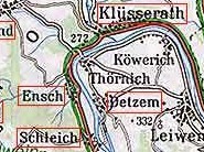 Kowerich is located in the southeastern portion of the study area. Data in this file covers the period of 1665 to 1875 from Catholic Church records in the area. The four closest towns around Kowerich are Thornich, Clusserath, Detzem, and Ensch. The six most common names in this file are Basten, Herres, Jacobi, Kowerich, Roles, and Thul. There are 1294 names in this file. If you want to look at the complete file, click on Kowerich.
 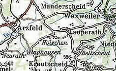 Krautscheid is located in the central portion of the study area. Data in this file covers the period of 1779 to 1861 from Catholic Church records in the area. The four closest towns around Ktautscheid are Windhausen, Lauperath, Bellscheid, and Aezfeld. The three most common names in this file are Hoffman, Melchior, and Meyer. There are 258 names in this file. If you want to look at the complete file, click on Krautscheid.
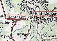 Kringhof located in the southeastern portion of the study area. Data in this file covers the period of 1798 to 1848 from Catholic Church records in Hontheim. The four closest towns around Kringhof are Bad Bertrich,Hontheim, Hetzhiff, and Wispelt. The three most common names in this file are Franzen, Pantenburg, and Thullen. There are 170 names in this file. If you want to look at the complete file, click on Kringhof.
 Kyllburg is located in the central portion of the study area. Data in this file covers the period of 1744 to 1881 from Catholic Church records in the area. The four closest towns around Kyllburg are Orsfeld, Wilsecker, Malberg, and Malbergweich. The 13 most common names in this file are Atzorn, Bitchegajo, Cometz, Cremer, Cronimus, Hoff, Horman, Lano, Mathei, Niederprum, Persy, Polich, and
Schmitz. There are 3739 names in this file. If you want to look at the complete file, click on Kyllburg.
Kyllburg is located in the central portion of the study area. Data in this file covers the period of 1744 to 1881 from Catholic Church records in the area. The four closest towns around Kyllburg are Orsfeld, Wilsecker, Malberg, and Malbergweich. The 13 most common names in this file are Atzorn, Bitchegajo, Cometz, Cremer, Cronimus, Hoff, Horman, Lano, Mathei, Niederprum, Persy, Polich, and
Schmitz. There are 3739 names in this file. If you want to look at the complete file, click on Kyllburg. 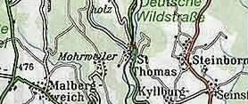 Kyllburgweiler is located in the central portion of the study area. Data in this file covers the period of 1771 to 1868 from Catholic Church records in the area. The four closest towns around Kyllburgweiler are St
Thomas, Seinsfeld, Kyllburg, and Malberg. The four most common names in this file are Backes, Keil, Pick, and Reuschen. There are 505 names in this file. If you want to look at the complete file, click on Kyllburgweiler.
Kyllburgweiler is located in the central portion of the study area. Data in this file covers the period of 1771 to 1868 from Catholic Church records in the area. The four closest towns around Kyllburgweiler are St
Thomas, Seinsfeld, Kyllburg, and Malberg. The four most common names in this file are Backes, Keil, Pick, and Reuschen. There are 505 names in this file. If you want to look at the complete file, click on Kyllburgweiler.