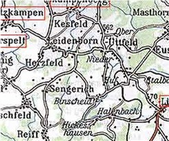
Geefs is located in the east-central portion of the study area. Data in this file covers the period of 1687 to 1895. from Catholic Church records in the area. The four closest towns around Geefs are Gerolstein, Neroth,
Berlingen, and Kirschweiler. The four most common names in this file are Eul, Jarding, Kohl, and Thomas. There are 732 names in this file. If you want to look at the complete file, click on Geefs.
 Geichlingen is located in the southern portion of the study area. Data in this file covers the period of 1687 to 1895. from Catholic Church records in the area. The four closest towns around Geichlingen are Bauler, Lahr, Mettendorf, and Nasingen. The seven most common names in this file are Bermes, Himbler, Kauth, Meyer, Nosbisch, Pals, and Theis. There are 940 names in this file. If you want to look at the complete file, click on Geichlingen.
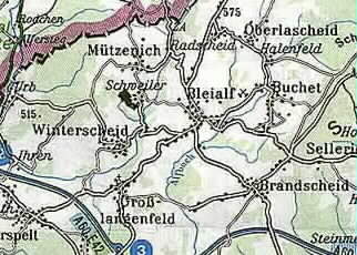
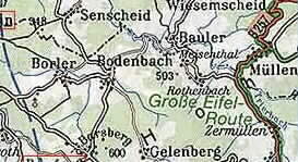 Gelenberg is located in the eastern portion of the study area. Data in this file covers the period of 1687 to 1895. from Catholic Church records in the area. The four closest towns around Gelenberg are Kelberg,
Bodenbach, Bongard, Zermullen. The three most common names in this file are Blick, Eich, and Heinz. There are 331 names in this file. If you want to look at the complete file, click on Gelenberg.
Gelenberg is located in the eastern portion of the study area. Data in this file covers the period of 1687 to 1895. from Catholic Church records in the area. The four closest towns around Gelenberg are Kelberg,
Bodenbach, Bongard, Zermullen. The three most common names in this file are Blick, Eich, and Heinz. There are 331 names in this file. If you want to look at the complete file, click on Gelenberg.  Gelsdorf is located in the eastern portion of the study area. Data in this file covers the period of 1738 to 1875 from Catholic Church records in the area. The closest town around Gelsdorf is Gransdorf. The two most common names in this file are Becker and Kreutz. There are 80 names in this file. If you want to look at the complete file, click on Gelsdorf.
  Gemund is located in the southeastern portion of the study area. Data in this file covers the period of 1808 to 1875. from Catholic Church records in the area. The four closest towns around Gemund are Dauwelhausen, Rodeshausen, Obereisenbach, and Waldhof. The four most common names in this file are Grotius. onweiler, Scheuren, and Theis. There are 320 names in this file. If you want to look at the complete file, click on Gemund.
 Gemunden is located in the northeastern portion of the study area. Data in this file covers the period of 1741 to 1862 from Catholic Church records in the area. The four closest towns around Gemunden are Putzborn, Mehren, Daun, and Neunkirchen. The three most common names in this file are Meyer, Neuman, and Schreiner. There are 223 names in this file. If you want to look at the complete file, click on Gemunden.
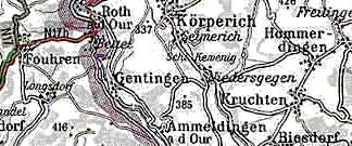 Gentingen is located in the southern portion of the study area. Data in this file covers the period of 1687 to 1895. from Catholic Church records in the area. The four closest towns around Fleringen are Korperich, Cruchten, Niedergegen, and Ammeldingen. The three most common names in this file are Borman, Henckels, and Wagener. There are 346 names in
this file. If you want to look at the complete file, click on Gentingen.
Gentingen is located in the southern portion of the study area. Data in this file covers the period of 1687 to 1895. from Catholic Church records in the area. The four closest towns around Fleringen are Korperich, Cruchten, Niedergegen, and Ammeldingen. The three most common names in this file are Borman, Henckels, and Wagener. There are 346 names in
this file. If you want to look at the complete file, click on Gentingen.
 Gerolstein is located in the eastern portion of the study area. Data in this file covers the period of 1687 to 1895 from Catholic Church records in the area. The four closest towns around Gerolstein are Mullenborn, Eich, Berlingen, and Geefs. The 10 most common names in this file are Claus, Clemens, Cosman, Daubach, Koch, Kohl, Meyer, Roskopf, Schildgen,
and Schneider. There are 2498 names in this file. If you want to look at the complete file, click on Gerolstein.
Gerolstein is located in the eastern portion of the study area. Data in this file covers the period of 1687 to 1895 from Catholic Church records in the area. The four closest towns around Gerolstein are Mullenborn, Eich, Berlingen, and Geefs. The 10 most common names in this file are Claus, Clemens, Cosman, Daubach, Koch, Kohl, Meyer, Roskopf, Schildgen,
and Schneider. There are 2498 names in this file. If you want to look at the complete file, click on Gerolstein.
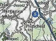 Gesotz is located in the central portion of the study area. Data in this file covers the period of 1808 to 1874 from Catholic Church records in the area. The four closest towns around Gesotz are Pintesfeld, Lascheid, Feuerscheid, and Hargarten. The two most common names in this file are Scherts and Steils. There are 34 names in this file. If you want to look at the complete file, click on Gesotz.
 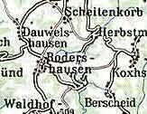 Geymuhlen is located in the eastern portion of the study area. Data in this file covers the period of 1819 to 1875 from Catholic Church records in the area. The closest town around Geymuhlen is Rodershausen. The two most common names in this file are Fischbach and Theis. There are 51 names in this file. If you want to look at the complete file, click on Geymehlen.
 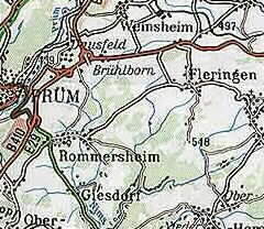 Giesdorf is located in the central portion of the study area. Data in this file covers the period of 1687 to 1895. from Catholic Church records in the area. The four closest towns around Giesdorf are Rommersheim, Prum, Schonecken, and Hersdorf. The three most common names in
this file are Ernst, Hoffman, and Reiffers. There are 312 names in this file. If you want to look at the complete file, click on Giesdorf.
Giesdorf is located in the central portion of the study area. Data in this file covers the period of 1687 to 1895. from Catholic Church records in the area. The four closest towns around Giesdorf are Rommersheim, Prum, Schonecken, and Hersdorf. The three most common names in
this file are Ernst, Hoffman, and Reiffers. There are 312 names in this file. If you want to look at the complete file, click on Giesdorf.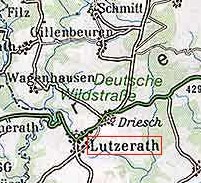 Gillenbeuren is located in the eastern portion of the study area. Data in this file covers the period of 1723 to 1798 from Catholic Church records in the area. The four closest towns around Gillenbeauren are Schmii Filz, Wagenhausen,and Lutzerath. The five most common names in
this file are Bens, Kefseler, Mertes, Osterman, and Theobald. There are 320 names in this file. If you want to look at the complete file, click on Gillenbeuren.
Gillenfeld is located in the central portion of the study area. Data in this file covers the period of 1730 to 1895 from Catholic Church records in the area. The four closest towns around Gillenfeld are Udler, Eckfeld, Brockscheid, and Strohn. The 11 most common names in
this file are Borsch, Diewald, Hammes, Jungen, Maas, Meeth, Otten, Rauen,Schaeffer, Weber, and Zilligen. There are 3536 names in this file. If you want to look at the complete file, click on Gillenfeld.
Gillenbeuren is located in the eastern portion of the study area. Data in this file covers the period of 1723 to 1798 from Catholic Church records in the area. The four closest towns around Gillenbeauren are Schmii Filz, Wagenhausen,and Lutzerath. The five most common names in
this file are Bens, Kefseler, Mertes, Osterman, and Theobald. There are 320 names in this file. If you want to look at the complete file, click on Gillenbeuren.
Gillenfeld is located in the central portion of the study area. Data in this file covers the period of 1730 to 1895 from Catholic Church records in the area. The four closest towns around Gillenfeld are Udler, Eckfeld, Brockscheid, and Strohn. The 11 most common names in
this file are Borsch, Diewald, Hammes, Jungen, Maas, Meeth, Otten, Rauen,Schaeffer, Weber, and Zilligen. There are 3536 names in this file. If you want to look at the complete file, click on Gillenfeld.
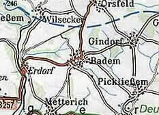 Gindorf is located in the southeastern portion of the study area. Data in this file covers the period of 1687 to 1895. from Catholic Church records in the area. The four closest towns around Gindorf are Gransdorf, Badem, Orsfeld, and Wilsecker. The five most common names in this file are
Berscheid, Franzen, Grosdidier, Meyer, and Probst. There are 871 names in this file. If you want to look at the complete file, click on Gindorf.
Gindorf is located in the southeastern portion of the study area. Data in this file covers the period of 1687 to 1895. from Catholic Church records in the area. The four closest towns around Gindorf are Gransdorf, Badem, Orsfeld, and Wilsecker. The five most common names in this file are
Berscheid, Franzen, Grosdidier, Meyer, and Probst. There are 871 names in this file. If you want to look at the complete file, click on Gindorf.  Ginneburg is located in the southern portion of the study area. Data in this file covers the period of 1731 to 1820 from Catholic Church records in the area. The closest town around Ginneburg is Schleid. The two most common names in this file are Funk and Hau. There are 30 names in this file. If you want to look at the complete file, click on Ginneburg.
 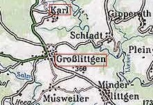 Gipperath is located in the eastern portion of the study area. Data in this file covers the period of 1748 to 1798 from Catholic Church records in the area. The four closest towns around Gipperath is Schladt, Pleien, Niederufflingen, and Karl. The three most common names in this file are Coller, Fohrens, and Niles. There are 113 names in this file. If you want to look at the complete file, click on Gipperath.
 Glaadt is located in the northern portion of the study area. Data in this file covers the period of 1687 to 1895 from Catholic Church records in the area. The four closest towns around Glaadt are Junkerath, Stadtkyll, Esch, and Feusdorf. The six most common names in this file are Cremer, Kaufman, Klein, Kreisch, Nellefsen, and Pheil. There are 1082 names in
this file. If you want to look at the complete file, click on Glaadt.
Glaadt is located in the northern portion of the study area. Data in this file covers the period of 1687 to 1895 from Catholic Church records in the area. The four closest towns around Glaadt are Junkerath, Stadtkyll, Esch, and Feusdorf. The six most common names in this file are Cremer, Kaufman, Klein, Kreisch, Nellefsen, and Pheil. There are 1082 names in
this file. If you want to look at the complete file, click on Glaadt.
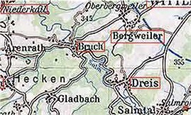 Gladtbach is located in the southeastern portion of the study area. Data in this file covers the period of 1687 to 1895 from Catholic Church records in the area. The four closest towns around Gladtbach area Dreis, Bruck, Arenrath, and Salmtal. The seven most common names in this file are Bauman, Heintz, Linden, Plein, Schoenhoven, Valerius, and Vollman. There are 471 names in this file. If you want to look at the complete file, click on Gladtbach.
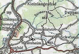 Gondelsheim is located in the central portion of the study area. Data in this file covers the period of 1687 to 1895. from Catholic Church records in the area. The four closest towns around Gondelsheim are Schwirzheim, Weinsheim,Hermespand, and Ponsfeld. The eight most common names in this file are Backes, Friedericks, Grofsman, Heinzen, Meyer, otten, Peters, and Schmitz. There are 1034 names in this file. If you want to look at the complete file, click on Gondelsheim.
 Gondenbrett is located in the central portion of the study area. Data in this file covers the period of 1687 to 1895. from Catholic Church records in the area. The four closest towns around Gondenbrett are Hermespand, Wilwerath, Mehlen, and Dausfeld. The seven most common names in this file are Berends, Haas, Leuschen, Mertes, Meyer, Muller, and Thelen. There are 956 names in this file. If you want to look at the complete file, click on Gondenbrett.


Goennersdorf is located in the central portion of the study area. Data in this file covers the period of 1687 to 1895. from Catholic Church records in the area. The four closest towns around Goennersdorf are Birgel, Schuller, Lissendorf, and Feusdorf. The six most common names in this file are Demary, Eich, feyen, Hilgers, Hoffman, and Michels. There are 792 names in this file. If you want to look at the complete file, click on Goennersdorf.

 Graach is located in the southeastern portion of the study area. Data in this file covers the period of 1690 to 1848 from Catholic Church records in the area. The four closest towns around Graach are Wehlen, Trarbach, Zeltingen, and Maring. The 10 most common names in this file are Bernard, Beucher, Christman, Ehlen, Geller, Kieren, Meyer, Phillips, Schefer, and Velten. There are 2848 names in this file. If you want to look at the complete file, click on Graach.
 Gransdorf is located in the eastern portion of the study area. Data in this file covers the period of 1687 to 1895. from Catholic Church records in the area. The four closest towns around Gransdorf are Oberkail, Schwarzenborn, Eisenschmitt, and Gindorf. The 10 most common names in this file are Becker, Cremer, Engel, Etteldorf, Kohl, Kolhey, Kreutz,
Meyer, Schmitt, and Stuckart. There are 1957 names in this file. If you want to look at the complete file, click on Gransdorf.
Gransdorf is located in the eastern portion of the study area. Data in this file covers the period of 1687 to 1895. from Catholic Church records in the area. The four closest towns around Gransdorf are Oberkail, Schwarzenborn, Eisenschmitt, and Gindorf. The 10 most common names in this file are Becker, Cremer, Engel, Etteldorf, Kohl, Kolhey, Kreutz,
Meyer, Schmitt, and Stuckart. There are 1957 names in this file. If you want to look at the complete file, click on Gransdorf.
 Greverath is located outside the southwester edge of the study area. Data in this file covers the period of 1710 to 1870 from Catholic Church records in the area. The four closest towns around Greverath are Dodenburg, Gladbach, Munster, and Niersbach. The six most common names in this file are Ballman, Becker, Klosen, Michels, Richerz, and Welter. There are 533 names in this file. If you want to look at the complete file, click on Greverath.
 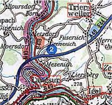 Grevenich is located in the southern portion of the study area. Data in this file covers the period of 1710 to 1860 from Catholic Church records in the area. The four closest towns around Grevenich are Metzdorf, Hinkel, Fusenich, and Mesenich. The four most common names in this file are Clafsen, Hansen, Lauer, and Peters. There are 319 names in this file. If you want to look at the complete file, click on Grevenich.