Aach
 Aach is located in the southern portion of the study area. Data in this file covers the period of 1691 to 1872 from Catholic Church records in the area. The four closest towns around Aach are Besselich, Hohensonne, Lorich, and Sirzenich. The nine most common names in this file are Endres, Feilen, Feltes, Kersch, Krein, Lorich, Roth, Trierweiler, and Willems. There are 1120 names in this file. If you want to look at the complete file, click on Aach.
Achterburg
Aach is located in the southern portion of the study area. Data in this file covers the period of 1691 to 1872 from Catholic Church records in the area. The four closest towns around Aach are Besselich, Hohensonne, Lorich, and Sirzenich. The nine most common names in this file are Endres, Feilen, Feltes, Kersch, Krein, Lorich, Roth, Trierweiler, and Willems. There are 1120 names in this file. If you want to look at the complete file, click on Aach.
Achterburg
 Achterburg is located in the central portion of the study area.
Miscellaneous data in this file covers the period of 1813 to 1865 from Catholic Church records in the area. The closest town around Achterburg is Ehlenz. The most common name in this file is Himpeler. There are 18 names in this file. If you want to look at the complete file, click on Achterburg.
Affler
Achterburg is located in the central portion of the study area.
Miscellaneous data in this file covers the period of 1813 to 1865 from Catholic Church records in the area. The closest town around Achterburg is Ehlenz. The most common name in this file is Himpeler. There are 18 names in this file. If you want to look at the complete file, click on Achterburg.
Affler
 Affler is located in the western portion of the study area.
Data in this file covers the period of 1705 to 1870 from Catholic Church
records in the area. The four closest towns around Affler are Preischeid, Ubereisenbach, Scheitenkorb, and Sevenig. The five most common names in this file are Biffens, Jost, Praus, Steffes, and Theis. There are 195 names in this file. If you want to look at the complete file, click on Affler.
Ahutte
Affler is located in the western portion of the study area.
Data in this file covers the period of 1705 to 1870 from Catholic Church
records in the area. The four closest towns around Affler are Preischeid, Ubereisenbach, Scheitenkorb, and Sevenig. The five most common names in this file are Biffens, Jost, Praus, Steffes, and Theis. There are 195 names in this file. If you want to look at the complete file, click on Affler.
Ahutte
 Ahutte is located in the north portion of the study area.
Data in this file covers the period of 1804 to 1868 from Catholic Church
records in the area. The two closest towns around Ahutte are Leuderdorf and Uxheim. The two most common names in this file are Dreimuller and Henseler. There are 262 names in this file. If you want to look at the complete file, click on Ahutte.
Ahrhutte
Ahutte is located in the north portion of the study area.
Data in this file covers the period of 1804 to 1868 from Catholic Church
records in the area. The two closest towns around Ahutte are Leuderdorf and Uxheim. The two most common names in this file are Dreimuller and Henseler. There are 262 names in this file. If you want to look at the complete file, click on Ahutte.
Ahrhutte
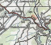 Ahrhutte is located in the north portion of the study area.
Data in this file covers the period of 1680 to 1875 from Catholic Church
records in the area. The four closest towns around Ahrhutte are Dollendorf, Lommersdorf, Ahrdorf,and Hungersdorf. The seven most common names in this file are Dreimuller, Gieffer, Miefs, Muer, Pick, Reinartz,
and Weiskopf. There are 414 names in this file. If you want to look at the complete file, click on Ahrhutte.
Aldegund
Ahrhutte is located in the north portion of the study area.
Data in this file covers the period of 1680 to 1875 from Catholic Church
records in the area. The four closest towns around Ahrhutte are Dollendorf, Lommersdorf, Ahrdorf,and Hungersdorf. The seven most common names in this file are Dreimuller, Gieffer, Miefs, Muer, Pick, Reinartz,
and Weiskopf. There are 414 names in this file. If you want to look at the complete file, click on Ahrhutte.
Aldegund
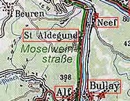 Aldegund is located in the eastern portion of the study area. Data in this file covers the period of 1806 to 1838 from Catholic Church records in the area. The four closest towns around Aldegund are Neeb, Bremm, Bullay, and Alf. The ten most common names in this file are xxxx.. There are 351 names in this file. If you want to look at the complete file, click on
Aldegund.
Aldegund is located in the eastern portion of the study area. Data in this file covers the period of 1806 to 1838 from Catholic Church records in the area. The four closest towns around Aldegund are Neeb, Bremm, Bullay, and Alf. The ten most common names in this file are xxxx.. There are 351 names in this file. If you want to look at the complete file, click on
Aldegund.
Alendorf
 Alendorf is located in the northern portion of the study area. Data in this file covers the period of 1701 to 1875 from Catholic Church records in the area. The four closest towns around Alendorf are Dollendorf, Mirbach, Esch, and Ripsdorf. The ten most common names in this file are Bach, Gentges, Hansen, Meyer, Miefs, Molitor, Reifferscheid, Schaeffer, Schmitz, and Vogelsberg. There are 1116 names in this file. If you want to look at the complete file, click on
Alendorf.
Alendorf is located in the northern portion of the study area. Data in this file covers the period of 1701 to 1875 from Catholic Church records in the area. The four closest towns around Alendorf are Dollendorf, Mirbach, Esch, and Ripsdorf. The ten most common names in this file are Bach, Gentges, Hansen, Meyer, Miefs, Molitor, Reifferscheid, Schaeffer, Schmitz, and Vogelsberg. There are 1116 names in this file. If you want to look at the complete file, click on
Alendorf.
Alf
 Alf is located in the central portion of the study area.
Miscellaneous data in this file covers the period of 1847 to 1871 from Catholic Church records in the area. The closest town to Alf is Emmelbaum. The most common name in this file is Meyer. There are 17 names in this file. If you want to look at the complete file, click on Alf.
Alf near Bullay
Alf near Bullay is located in the northeast portion of the study area.
Data in this file covers the period of 1630 to 1850 from Catholic Church records in the area. The closest towns to Alf to Bullay are Bullay, Aldegund, Zell, and Breidel. The most common name in this file is xxxx. There are 3866 names in this file. If you want to look at the complete file, click on Alf near Bullay.
Alflen
Alf is located in the central portion of the study area.
Miscellaneous data in this file covers the period of 1847 to 1871 from Catholic Church records in the area. The closest town to Alf is Emmelbaum. The most common name in this file is Meyer. There are 17 names in this file. If you want to look at the complete file, click on Alf.
Alf near Bullay
Alf near Bullay is located in the northeast portion of the study area.
Data in this file covers the period of 1630 to 1850 from Catholic Church records in the area. The closest towns to Alf to Bullay are Bullay, Aldegund, Zell, and Breidel. The most common name in this file is xxxx. There are 3866 names in this file. If you want to look at the complete file, click on Alf near Bullay.
Alflen
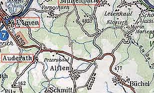 Alflen is located in the eastern portion of the study area.
Data in this file covers the period of 1800 to 1852 from Catholic Church
records in the area. The four closest towns around Alflen are Auderath, Schmitt, Buchel, and Gillenbeuren. The xx most common names in this file are xxx. There are 648 names in this file. If you want to look at the complete file, click on Alflen.
Alsdorf
Alflen is located in the eastern portion of the study area.
Data in this file covers the period of 1800 to 1852 from Catholic Church
records in the area. The four closest towns around Alflen are Auderath, Schmitt, Buchel, and Gillenbeuren. The xx most common names in this file are xxx. There are 648 names in this file. If you want to look at the complete file, click on Alflen.
Alsdorf
 Alsdorf is located in the southern portion of the study area.
Data in this file covers the period of 1782 to 1852 from Catholic Church
records in the area. The four closest towns around Alsdorf
are Peffingen, Holsthun, Meckel, and Wolsfeld. The four
most common names in this file are Bier, Kauth, Klein, and Schmitt. There are 525 names in this file. If you want to look at the complete file, click on Alsdorf.
Altenhof
Alsdorf is located in the southern portion of the study area.
Data in this file covers the period of 1782 to 1852 from Catholic Church
records in the area. The four closest towns around Alsdorf
are Peffingen, Holsthun, Meckel, and Wolsfeld. The four
most common names in this file are Bier, Kauth, Klein, and Schmitt. There are 525 names in this file. If you want to look at the complete file, click on Alsdorf.
Altenhof
 Altenhof is located in the south-central portion of the study
area. Data in this file covers the period of 1741 to 1849 from partial Catholic Church records in the area. The four closest towns around Altenhof are Eisenschmitt, Hau, Schwarzenborn, and Landscheid.
The six names in this file are Hufs, Nufges, Peifer, Rausch, Schellen, and Weber. There are 45 names in this file. If you want to look at the complete file, click on Altenhof.
Altenhof is located in the south-central portion of the study
area. Data in this file covers the period of 1741 to 1849 from partial Catholic Church records in the area. The four closest towns around Altenhof are Eisenschmitt, Hau, Schwarzenborn, and Landscheid.
The six names in this file are Hufs, Nufges, Peifer, Rausch, Schellen, and Weber. There are 45 names in this file. If you want to look at the complete file, click on Altenhof.
Altscheid
 Altscheid is located in the southern portion of the study area.
Data in this file covers the period of 1721 to 1875 from Catholic Church
records in the area. The four closest towns around Altscheid are Fischbach, Mierkeshausen,Wiersdorf, and Freilingen. The ten most common names in this file are Endres,Hansen, Heltemes, Jacobs, Kootz, Noesges, Nosbers, Putz, Schiltz, and Thelen. There are 534 names in this file. If you want to look at the complete file, click on Altscheid.
Altrich
Altscheid is located in the southern portion of the study area.
Data in this file covers the period of 1721 to 1875 from Catholic Church
records in the area. The four closest towns around Altscheid are Fischbach, Mierkeshausen,Wiersdorf, and Freilingen. The ten most common names in this file are Endres,Hansen, Heltemes, Jacobs, Kootz, Noesges, Nosbers, Putz, Schiltz, and Thelen. There are 534 names in this file. If you want to look at the complete file, click on Altscheid.
Altrich
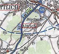 Altrich is located in the southern portion of the study area. Data in this file covers the period of 1709 to 1870 from Catholic Church records in the area. The four closest towns around Altrich are Wittlich, Bergweiler, Haardt, and Buescheidt. The nine most common name in this file are Braun, Gombeler, Graf, Lehnen, Loewen, Marman, Muller, Spang, and Zimmer. There are 1573 names in this file. If you want to look at the complete file, click on Altrich.
Altseiffen
Altrich is located in the southern portion of the study area. Data in this file covers the period of 1709 to 1870 from Catholic Church records in the area. The four closest towns around Altrich are Wittlich, Bergweiler, Haardt, and Buescheidt. The nine most common name in this file are Braun, Gombeler, Graf, Lehnen, Loewen, Marman, Muller, Spang, and Zimmer. There are 1573 names in this file. If you want to look at the complete file, click on Altrich.
Altseiffen
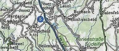 Altseiffen is located in the central portion of the study area.
Data in this file covers the period of 1804 to 1847 from Catholic Church
records in the area. The closest town to Altseiffen is Pluttscheid. The two most common names in this file are Bach and Hoffman. There are 28 names in this file. If you want to look at the complete file, click on Altseiffen.
Ammeldingen
Altseiffen is located in the central portion of the study area.
Data in this file covers the period of 1804 to 1847 from Catholic Church
records in the area. The closest town to Altseiffen is Pluttscheid. The two most common names in this file are Bach and Hoffman. There are 28 names in this file. If you want to look at the complete file, click on Altseiffen.
Ammeldingen
 Ammeldingen located in the southeastern portion of the study
area. Data in this file covers the period of 1666 to 1860 from Catholic Church records in the area. The following microfilm from the Family History Library was used in the development of this data base : 0530206, 0558657, 0825753, and 0531303. The four closest towns around Ammeldingen
are Cruchten, Biesdorf, Gentingen, and Wallendorf. The three most common names in this file are Biwer, Glasener, and Roder. There are
269 names in this file. If you want to look at the complete file, click on Ammeldingen.
Ammelscheid
Ammeldingen located in the southeastern portion of the study
area. Data in this file covers the period of 1666 to 1860 from Catholic Church records in the area. The following microfilm from the Family History Library was used in the development of this data base : 0530206, 0558657, 0825753, and 0531303. The four closest towns around Ammeldingen
are Cruchten, Biesdorf, Gentingen, and Wallendorf. The three most common names in this file are Biwer, Glasener, and Roder. There are
269 names in this file. If you want to look at the complete file, click on Ammeldingen.
Ammelscheid
 Ammelscheid is located in the northwestern border of the study area. Data in this file covers the period of 1740 to 1800 from Catholic Church records in the area. The four closest towns around Ammelscheid are Mutzenich, Radscheid, Atzerath, and Meckenbach. The five most common names in this file are Arens, Cremer, Heunen, Michels, and Quetsch. There are 147 names in this file. If you want to look at the complete file, click on Ammelscheid.
Andel
Ammelscheid is located in the northwestern border of the study area. Data in this file covers the period of 1740 to 1800 from Catholic Church records in the area. The four closest towns around Ammelscheid are Mutzenich, Radscheid, Atzerath, and Meckenbach. The five most common names in this file are Arens, Cremer, Heunen, Michels, and Quetsch. There are 147 names in this file. If you want to look at the complete file, click on Ammelscheid.
Andel
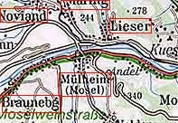 Andel is located in the southern portion of the study area. Data in this file covers the period of 1706 to 1798 from Catholic Church records in the area. The four closest towns around Andel are Kues, Mulheim nr Wittlich, Lieser, and Monzelfeld. The most common name in this file is Lobuscher. There are 30 names in this file. If you want to look at the complete file, click on Andel.
Antweiler
Andel is located in the southern portion of the study area. Data in this file covers the period of 1706 to 1798 from Catholic Church records in the area. The four closest towns around Andel are Kues, Mulheim nr Wittlich, Lieser, and Monzelfeld. The most common name in this file is Lobuscher. There are 30 names in this file. If you want to look at the complete file, click on Andel.
Antweiler
 Antweiler is located in the north portion of the study area.
Data in this file covers the period of 1720 to 1875 from Catholic Church
records in the area. The four closest towns around Antweiler are Musch, Reifferscheid, Aremberg, and Rodder. The 10 most common names in this file are Derards, Ginster, Gutthausen, Kefsel, Michels, Muller, Osterprey, Sart, Weber, and Wirz. There are 1063 names in this file. If you want to look at the complete file, click on Antweiler.
Aremberg
Antweiler is located in the north portion of the study area.
Data in this file covers the period of 1720 to 1875 from Catholic Church
records in the area. The four closest towns around Antweiler are Musch, Reifferscheid, Aremberg, and Rodder. The 10 most common names in this file are Derards, Ginster, Gutthausen, Kefsel, Michels, Muller, Osterprey, Sart, Weber, and Wirz. There are 1063 names in this file. If you want to look at the complete file, click on Antweiler.
Aremberg
 Aremberg is located in the northern portion of the study area.
Data in this file covers the period of 1680 to 1875 from Catholic Church
records in the area. The following microfilm from the Family History Library was used in the development of this data base : 0566858, 0566859, and 0566861. The four closest towns around Aremberg are Ohlenhard, Antweiler, Freilingen, and Lommersdorf. The ten most common names in this file are Bichler, Jackelen, Kemper, Klein, Krings, Luxen, Nelles, Reuter, Udelhoven, and Wiesbaum. There are 1332 names in this file. If you want to look at the complete file, click on Aremberg.
Arsdorf
Aremberg is located in the northern portion of the study area.
Data in this file covers the period of 1680 to 1875 from Catholic Church
records in the area. The following microfilm from the Family History Library was used in the development of this data base : 0566858, 0566859, and 0566861. The four closest towns around Aremberg are Ohlenhard, Antweiler, Freilingen, and Lommersdorf. The ten most common names in this file are Bichler, Jackelen, Kemper, Klein, Krings, Luxen, Nelles, Reuter, Udelhoven, and Wiesbaum. There are 1332 names in this file. If you want to look at the complete file, click on Aremberg.
Arsdorf
 Arsdorf is located in the north portion of the study area.
Data in this file covers the period of 1800 to 1875 from Catholic Church
records in the area. The four closest towns around Arsdorf are Ahrhutte, Udelhoven, Dorsel, and Hoffeld. The five most common names in this file are Blum, Dorn, Gieffer,Illigen, and Nelles. There are 414 names in this file. If you want to look at the complete file, click on Arsdorf.
Arzfeld
Arsdorf is located in the north portion of the study area.
Data in this file covers the period of 1800 to 1875 from Catholic Church
records in the area. The four closest towns around Arsdorf are Ahrhutte, Udelhoven, Dorsel, and Hoffeld. The five most common names in this file are Blum, Dorn, Gieffer,Illigen, and Nelles. There are 414 names in this file. If you want to look at the complete file, click on Arsdorf.
Arzfeld
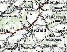 Arzfeld is located in the central portion of the study area.
Data in this file covers the period of 1690 to 1850 from Catholic Church
records in the area. The four closest towns around Arzfeld
are Neidenbach, Neuheilenbach, Burbach, and Neustrasburg.
The ten most common names in this file are Cremer, Grammes, Grasges, Hitzges, Linnetz, Meyer, Muller, Murschen, Theis, and Thelen. There are 1864 names in this file. If you want to look at the complete file, click on Arzfeld.
Auderath
Auderath is located in the eastern portion of the study area.
Data in this file covers the period of 1800 to 1852 from Catholic Church
records in the area. The four closest towns around Auderath are Alflen, Meiserich, Demerath, and Ulmen. The xx most common names in this file are xxx. There are 211 names in this file. If you want to look at the complete file, click on Auderath.
Auel
Arzfeld is located in the central portion of the study area.
Data in this file covers the period of 1690 to 1850 from Catholic Church
records in the area. The four closest towns around Arzfeld
are Neidenbach, Neuheilenbach, Burbach, and Neustrasburg.
The ten most common names in this file are Cremer, Grammes, Grasges, Hitzges, Linnetz, Meyer, Muller, Murschen, Theis, and Thelen. There are 1864 names in this file. If you want to look at the complete file, click on Arzfeld.
Auderath
Auderath is located in the eastern portion of the study area.
Data in this file covers the period of 1800 to 1852 from Catholic Church
records in the area. The four closest towns around Auderath are Alflen, Meiserich, Demerath, and Ulmen. The xx most common names in this file are xxx. There are 211 names in this file. If you want to look at the complete file, click on Auderath.
Auel
 Auel is located in the southern portion of the study area.
Data in this file covers the period of 1804 to 1860 from Catholic Church
records in the area. The four closest towns around Auel are Fischbach, Mierkeshausen, Wiersdorf, and Freilingen. The ten most common names in this file are Ahrens, Bauer, Bernardi, Dux, Fincken, Hoffman, Kunnen,
Mey, Renckes, and Serve. There are 235 names in this file. If you want to look at the complete file, click on Auel.
Auw bei Prum
Auel is located in the southern portion of the study area.
Data in this file covers the period of 1804 to 1860 from Catholic Church
records in the area. The four closest towns around Auel are Fischbach, Mierkeshausen, Wiersdorf, and Freilingen. The ten most common names in this file are Ahrens, Bauer, Bernardi, Dux, Fincken, Hoffman, Kunnen,
Mey, Renckes, and Serve. There are 235 names in this file. If you want to look at the complete file, click on Auel.
Auw bei Prum
 Auw bei Prum is located on the western border of the study area.
Data in this file covers the period of 1680 to 1798 from Catholic Church
records in the area. The following microfilm from the Family History Library was used in the development of this data base : 0849148 and 0561946. The four closest towns around Auw bei Prum are Kobscheid, Herzfenn, Verscheid, and Roth. The five most common names in this file are Clasen,Gorres, Heinen, Queims, and Schmitz. There are 1273 names in this file. If you want to look at the complete file, click on Auw bei Prum.
Auw an der Kyll
Auw bei Prum is located on the western border of the study area.
Data in this file covers the period of 1680 to 1798 from Catholic Church
records in the area. The following microfilm from the Family History Library was used in the development of this data base : 0849148 and 0561946. The four closest towns around Auw bei Prum are Kobscheid, Herzfenn, Verscheid, and Roth. The five most common names in this file are Clasen,Gorres, Heinen, Queims, and Schmitz. There are 1273 names in this file. If you want to look at the complete file, click on Auw bei Prum.
Auw an der Kyll
 Auw an der Kyll located in the southern portion of the study area.
Data in this file covers the period of 1701 to 1870 from Catholic Church
records in the area. The four closest towns around Auw an der Kyll are
Orenhoven, Hosten, Preist, and Trimport. The two most common names in this file are Kappes and Klinck. There are 177 names in this file. If you want to look at the complete file, click on Auw an der Kyll.
Auw an der Kyll located in the southern portion of the study area.
Data in this file covers the period of 1701 to 1870 from Catholic Church
records in the area. The four closest towns around Auw an der Kyll are
Orenhoven, Hosten, Preist, and Trimport. The two most common names in this file are Kappes and Klinck. There are 177 names in this file. If you want to look at the complete file, click on Auw an der Kyll.